
A mystery about Bay Ridge, Brooklyn, my hometown, was recently cleared, and I had Woody Allen, indirectly, to thank for it. Two separate websites, my childhood nerdiness, and the 1977 Academy Award-winning picture came together to solve a mystery that was in the back of my head for years.
I was a strange kid. If you’ve this column for eight years, and Forgotten New York for nearly 25, that comes as no surprise. However: while I had my share of friends as a kid, I was never the most popular and got bullied a lot, decades before pop and sports stars started making videos encouraging kids not to do it. My father was right about many things, and to his regret I wasn’t more athletic and chose to run off instead of confronting tormentors.
One of my odd habits was collecting as many street maps of NYC as I could (in those days, Hagstrom and Geographia pretty much dominated 90 percent of that market). Rand McNally’s NYC maps were inferior, and still are, and though there’s a large number of NYC mapmakers now (and I’m not even including the ones in the GPS devices) Hagstrom went to a computerized version years ago, while Geographia, a company about which I know very little—they’ve never done much publicity—has wisely stuck with the hand-drawn editions they have used for decades. In recent years, Google Maps has outpaced them all. Accept no substitutes: Apple’s maps are way inferior.
Geographia would also publish what they called Little Red Books not the philosophies espoused by “great helmsman” Mao Tse-Tung, but a list of all the streets in a borough, where they began and where they ended, what bus and train lines went there, and what the house numbers were. I pored through these Little Red Books like they were the Talmud, the Pentateuch, the Federalist Papers, the Necronomicon.
I also rode my bicycle to every nook and cranny in western Brooklyn, with an emphasis on Bay Ridge. I knew and still know where all the hidden alleys were, named and unnamed; I knew where the “haunted houses” were before the wrecker’s ball visited them; and I knew about the half-block long cemetery containing the bones of Revolutionary War fighters was (Narrows Ave. and Mackay Pl.).

Close by that little cemetery is Owl’s Head Park, a green oasis on a hill overlooking the Narrows, with views of Staten Island and the Verrazano Bridge. No one knows how the park got its name, though it’s speculated that the gateposts of an estate belonging to a senator who lived in the area sported a pair of carven owls’ heads. The parcel also belonged to an industrialist named Bliss, whose mansion was rudely removed by Robert Moses in 1940. When I was a kid, old-timers still called it Bliss Park. Brooklynite and former Fiery Furnace Eleanor Friedberger wrote the first song about Owl’s Head Park that I know of, and it’s affecting.

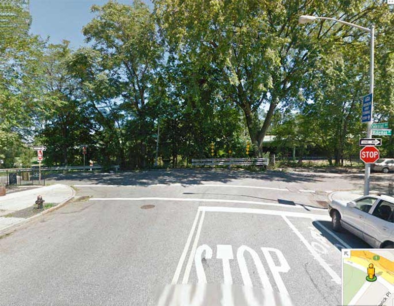
But Owls Head Park is not today’s mystery. When looking through the Little Red Book for Colonial Rd., the book stated that it ended at Wakeman Pl. and 1st Ave. My perambulations had already revealed that 1st Ave. ended at 58th St., at the gate of the Brooklyn Army Terminal, about eight blocks away. When I rode my bicycle to Colonial Rd. and Wakeman Pl., I found no trace of 1st Ave. Colonial Rd. ends abruptly, with no evidence of it continuing on as 1st Ave., as Ridge Blvd. continues north as 2nd Ave. a block east. I filed that Little Red Book listing away in my brain as an archaism or atavism that the book’s editors had never bothered to correct. It sat there, in the back of my brain, for over 30 years.
Then, in Nick Carr’s Scouting New York entry that lists the film settings of the Woody Allen/Diane Keaton classic Annie Hall and what the various NYC settings look like now, there’s a bit about stone eagles at the Central Park Zoo “that came from a 1912 bridge that went over Shore Road from First Avenue in Brooklyn. The eagles found their way to Central Park in 1941 after the bridge was demolished.”
Inquiring further about that bridge, I was directed to an Ephemeral New York listing that discussed it.

It was a magnificent arch bridge that carried Colonial Rd. over the twisting Shore Road Dr., which originally connected Shore Rd. and 4th Ave. but now serves as a feeder road for the Belt Parkway. Once over the drive and on the grounds of the Brooklyn Army Terminal, which opened in 1919, Colonial Rd. became 1st Ave. While the bridge, according to New York City Parks opened in 1912, traffic flow may have been restricted into the BAT as early as its opening in 1919.

So, Colonial Rd. once did turn into 1st Ave. at one time. But when the Belt Parkway was built by Robert Moses from 1938-1941, the bridge was destroyed, but the eagles wound up at the Central Park Zoo. And that’s how Woody Allen helped me clear up my confusion about an outdated listing in Geographia’s Little Red Book.
This 1929 atlas plate shows Owls Head Park, Colonial Road and its continuation north of Wakeman Pl.
—Kevin Walsh is the webmaster of the award-winning website Forgotten NY, and the author of the books Forgotten New York (HarperCollins, 2006) and also, with the Greater Astoria Historical Society, Forgotten Queens (Arcadia, 2013)