
There are a number of roads in NYC that go for lengthy stretches without interruption whatever, a cross street or a stoplight. There are plenty of parkways and expressways that go uninterrupted for miles, but I’m not talking about those; I’m referring to local streets. As a rule, you’ll find them in relatively depopulated areas.
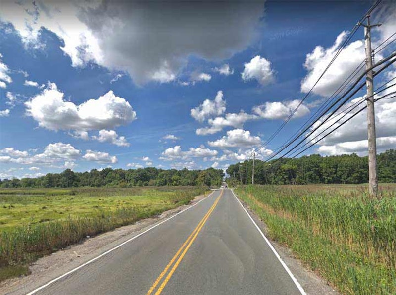
Above is Travis Ave. in southwest Staten Island, which plunges unimpeded through the William T. Davis Wildlife Refuge between Mulberry Ave. and Victory Blvd. I remember bicycling this stretch in 1977 when the MTA ran “bike buses” between Bay Ridge and Fingerboard Rd.—basically regular buses with the seats removed. I regularly used the service and roved all over the island on my bicycle. Few others did, however, and the bike bus was discontinued after one summer.
The 814-acre Davis Wildlife Refuge, named for a great Staten Island naturalist and entomologist, was New York City’s first such sanctuary, and was established by Davis in 1933. The park is about equal in size to Central Park. Much of the enclosure is a salt marsh that provides a rich milieu for flora and fauna. Over 100 bird species can be found here, including sharp-tailed sparrows, ducks, wading egrets, barn, great-horned and short-eared owls, many hawk varieties, as well as snapping turtles, crabs and muskrats. The Refuge features a nature trail entered at Travis Ave. near Mulberry Ave., and accommodates canoeists in the broad Main and Springville Creeks.

Riverdale is nestled along the Hudson River between Spuyten Duyvil on the south, Yonkers in the north and Van Cortlandt Park. With its curving, quiet lanes, spectacular views of the New Jersey Palisades and spectacular estates, it seems more a part of its neighbor to the north, suburban Westchester. The New York Times real estate section agrees: it has listed Riverdale separately from the rest of the Bronx for years. Yet, Riverdale has been a part of New York City since 1874, and the numbered street system that begins with E. 1st St. in the East Village extends to Riverdale’s city line at the Yonkers border at the highest numbered street in the series, W. 263rd St.
Palisade Ave. runs in two major pieces in Riverdale, from Edsall Ave. under the Henry Hudson Bridge north to Spaulding La. along the south end of Wave Hill, and again from W. 254th north to W. 261st. I’m picturing that northern section here, since it’s more “countrified” than the southerly section, without shoulders or sidewalks. Along this stretch there are driveways to various schools, as well as the entrance to semiprivate Sigma Pl., but it’s mostly a straightaway.

You’d never know you’re in the Bronx when driving up Shore Rd., which is a northeast extension of Pelham Parkway east of its spaghetti intersection with the New England Thruway and Hutchinson River Parkway. Shore Rd. keeps going through the east end of Pelham Bay Park, bridging over the Hutchinson River and rushing past the Bartow-Pell Mansion until attaining an uninterrupted stretch between the mansion and the Bronx-Westchester line. One of NYC’s secrets is that if you turn left on Roosevelt Ave. once within Pelham Manor and continue west, you’ll re-enter NYC briefly, as the avenue curves into NYC.

Brooklyn’s only “unimpeded” local street is Flatbush Ave., which has a pair of straightaways. Between Kings Plaza and the Belt Parkway and again from the Belt Parkway over the Marine Parkway Bridge, Flatbush Ave. doesn’t intersect any other street. Here, it runs past the main offices of Floyd Bennett Field; it flanks NYC’s first municipal airport and an unnamed area flanking Dead Horse Bay and Bottle Beach, a former landfill.
Constructed on the site of Barren Island and additional landfill, Floyd Bennett Field was New York City’s first municipal airport. The airport’s located in the southern part of Brooklyn between Flatbush Ave. and Jamaica Bay, and was completed in 1930 ( a smaller airfield, Barren Island Airport, had been there since the mid-1920s) and dedicated by Mayor Jimmy Walker. The airport initially had only two perpendicular runways. The terminal building was topped by an air traffic control tower and featured modern innovations such as underground tunnels extending from the basement to the ramp area. This allowed passengers to walk from the terminal to their aircraft in any weather. A barber shop, weather room, pilot’s lounge, passenger lounge, and restaurant were also part of the modern terminal (by the nascent airline industry standards).
Several miles north, there’s another uninterrupted stretch of Flatbush Ave. between Grand Army Plaza and Ocean Ave., where it bisects Prospect Park and the Brooklyn Botanic Gardens.

Perhaps Queens’ longest uninterrupted roadway is Cross Bay Blvd. between 165th Ave. in Howard Beach and 6th Rd/ in Broad Channel; it’s bridged over parts of Jamaica Bay and run past the Jamaica Bay Wildlife Refuge. After serving as Broad Channel’s main drag, it’s bridged over Jamaica Bay again via the Addabbo Bridge until reaching the Rockaway peninsula. The entire road was constructed in 1925 as a means of connecting the peninsula with Broad Channel and the rest of Queens. Cross Bay Blvd. is a southern extension of Woodhaven Blvd. south of Liberty Ave.

The south end of Brookville Blvd. in Rosedale, Queens between 147th Ave. and Rockaway Blvd. is isolated, a busy auto, truck and bus route running through the marshes of Hook Creek Park with no sidewalk or shoulder. This is the only north-south route connecting Rosedale with Rockaway Blvd. east of Guy Brewer Blvd.; east of here, Rockaway Blvd. plunges south past Meadowmere and into the Five Towns area of Nassau County. Springfield La. also intersected Rockaway Blvd., but that junction was severed in the 1970s.
It’s also a very old road. It has existed since the early-19th century when it was called Fosters Meadow Rd. and ran through a Queens County farming village of the same name.

While the north end of Manor Rd., Staten Island, runs through moderately populated Castleton Corners and past the Manor Road Armory, it beginnings were rural as it was named for the Manor Farm, one of the city’s leading equestrian centers. Manor Rd. retains a suburban aspect until south of Brielle Ave. in Willowbrook, where it assumes a completely rural appearance, running past the Pouch Boy Scout camp and the private Ohrbach Lake, zigzagging its way south to Rockland Ave. at Latourette Park. No sidewalks on that uninterrupted run.
—Kevin Walsh is the webmaster of the award-winning website Forgotten NY, and the author of the books Forgotten New York (HarperCollins, 2006) and also, with the Greater Astoria Historical Society, Forgotten Queens (Arcadia, 2013)