
A number of New York City streets feature states’ names. Not in concentrated blocs, like signers of the Declaration of Independence (Brooklyn), vestrymen of Trinity Church (Manhattan) New York City mayors (Bronx) or classical composers and astronauts (Staten Island). The Bronx once had a clump of streets named for important pressmen of the past.
New York City’s “state streets” are scattered around, while in some regions they are found in loose groupings. I’ve no idea why, in most cases, a particular state was so honored; perhaps a developer wished to honor his home state. Not every state is represented, and I’ll just list a prominent few. Though Dutch immigrants established some homes and farms in Brownsville and East New York in the 1700s, the area didn’t gel as a community until the early-to-middle 1800s. East New York was developed by John R. Pitkin, a Connecticut merchant beginning in 1835, while Brownsville is named for Charles S. Brown, who subdivided it in 1865. By 1890 its street arrangement and names had been settled on for the most part.
What you notice are two separate sections of “state streets:” one with southern states, Alabama, Georgia, Louisiana, and another with northeast states such as Massachusetts and Pennsylvania.
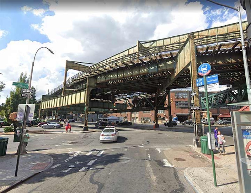
Seen above is the north end of Alabama Ave. at Fulton St., where the Broadway el (the J train) makes a turn from Broadway onto Fulton. The line connects Broad St. in Manhattan with Parsons-Archer in Jamaica. This is a major elevated and subway interchange.

It’s a mystery to me why there’s an Alaska St. in West Brighton, running from Richmond Terrace south to Castleton Ave. The clump of trees on the left are in an abandoned cemetery called, naturally, Staten Island Cemetery. This isn’t the sole reference to Alaska or the Great North on the Staten Island map. In New Springville, near Staten Island Mall, a group of streets are named Klondike, Nome, Platinum and Yukon.

Mill Basin is way out there by Brooklyn standards, just northeast of Kings Plaza but on a peninsula defined by the waterways Mill Basin and East Mill Basin, and accessible from Ave. U only by E. 63rd through 66th St. and by Mill Ave. The streets are laid out in strict semi-circles, the only NYC neighborhood other than Rego Park in Queens to do so. Some of NYC’s most luxurious and yet eclectic homes can be found in Mill Basin, such as the residence above at Arkansas Dr. and Bassett Ave.

Unlike other “state streets” found in Staten Island, Delaware Ave. stands alone in Dongan Hills, with no other “state streets” accompanying it. Pictured is Delaware Ave. at Hylan Blvd., where we find Rab’s Country Lanes, here for over a quarter century. Owner Rab Wilkinson, who died in 2008 and a pro bowler himself, helped local organizations raise over $500,000 through fundraisers and events, and was rewarded with a street corner named for him.
Meanwhile, though Flushing is known for its “plant streets” from Ash to Rose that commemorate the area’s former plant nurseries, the pattern has its exceptions and Delaware Ave. is one, slotted in between Cherry and Elm (further west, at the Queens Botanical Garden, the D street is Dahlia Avenue). I’m familiar with Delaware Ave.; I lived in the area from 1993 to 2007.

This defunct bank, on Atlantic and Georgia Aves. in East New York, was built before consolidation in 1898, and so reflected that this was the local bank of the 26th Ward. New York City used to have political designations called wards, which were the smallest political units in NYC. Each ward elected an alderman and an assistant alderman to the City Council. According to The Encyclopedia Of New York City (1995, Yale University Press) the system goes back to 1686, when Governor Thomas Dongan divided the city, then entirely in Manhattan, into six wards. In 1791, wards were given numerical designations. The First Ward was the tip of Manhattan, and districts were given consecutive numbers the further north you went in Manhattan. New wards were added as the city expanded northward, and increasing population of the older wards required subdivision. Brooklyn was also composed of wards. When it became a city in 1837, it was divided into nine wards, and by the time of consolidation with NYC in 1898 it had 32 wards.
One can be glad this bit of history was preserved, and be unhappy about the object plopped on top of it about 20 years ago.

In central Staten Island there’s a place whose original residents were dedicated to stamping out demon liquor years before the Volstead Act did the deed from 1919 to 1933. Developed in 1887 by Christopher S. Williams and William H. Boole, who purchased acreage from John Vanderbilt and created a summer retreat known as the National Prohibition Campground Association, what’s now Westerleigh was known as Prohibition Park and was lined with narrow, brick streets and one-family houses, some of them in ornate Victorian style. Most of the streets in Westerleigh are named for Presidential/Vice Presidential candidates of the Prohibition Party, such as Neal Dow (1880) John St. John (1884), Clinton B. Fisk (1888), John Bidwell (1892) and John Woolley (1900). “Dry” states in the 19th century like Maine, Ohio, New York, Colorado and Delaware are also featured on the Westerleigh map. The neighborhood takes its present name from the Westerleigh Collegiate Institute, formed in 1895; the institute was the first in Staten Island to provide an education from kindergarten to the collegiate level. College Ave. was named for it.
A walk through Westerleigh will reward you with sightings of the very best of classic late-19th century residential architecture.

Massachusetts St. in Tottenville, Staten Island borders Conference House Park, where a 17th-century home built by the Billopp family hosted a peace conference with British general to stave off a war, unsuccessfully.
A brick mansion built by British Royal Navy Captain Christopher Billopp at about 1680 (the date changes depending on the source) at the end of what would be Hylan Blvd. was almost a century old on September 11, 1776 when Benjamin Franklin, John Adams, and Edward Rutledge met here with Admiral Lord Richard Howe, representing King George III, in an attempt to end any future hostilities. While Howe proffered an offer from George III to grant the patriots more rights than other British colonies had if they ended their fight for liberty, Franklin and the others stood firm and insisted upon American independence. Fighting continued and NYC remained occupied by the British for the next seven years.

New York Ave. is the lengthiest of NYC’s state streets, running, with one interruption, from Fulton St. south to Ave. N. The trip takes it past Kings County Hospital, seen here. It’s one of NYC’s oldest hospitals, with a lineage stretching back to 1830, when this was part of the Town of Flatbush, not NYC.
New York Ave. is of course named for the city, not the state, but they all count! It’s part of a Brooklyn street-naming scheme in which north-south avenues were named for New York State cities, progressing east from those closest to NYC: hence New York and Brooklyn Aves. first, and ending with Buffalo Ave.

It doesn’t turn up on street signs… just three separate addresses of buildings constructed along Water St. in downtown Manhattan in the 1970s, #1, 2 and 4 New York Plaza; the name must have been cooked up by real estate developers to unify the region. The brown building with the thin windows in the rear was home to Manufacturers Hanover, now Chase, and my mother worked there for a few years after it opened and before her death.
—Kevin Walsh is the webmaster of the award-winning website Forgotten NY, and the author of the books Forgotten New York (HarperCollins, 2006) and also, with the Greater Astoria Historical Society, Forgotten Queens (Arcadia, 2013)