
New York City’s well-known streets are familiar: Broadway and 5th Ave. in Manhattan, Flatbush Ave. in Brooklyn, Queens Blvd., Grand Concourse in the Bronx, and perhaps Hylan Blvd., Staten Island’s lengthiest road. But there are also streets that are nearly invisible: old and left over from the colonial era that the city never bothered to eliminate, or streets at the city borders, and those that were paved over years ago that the city still marks with signs.
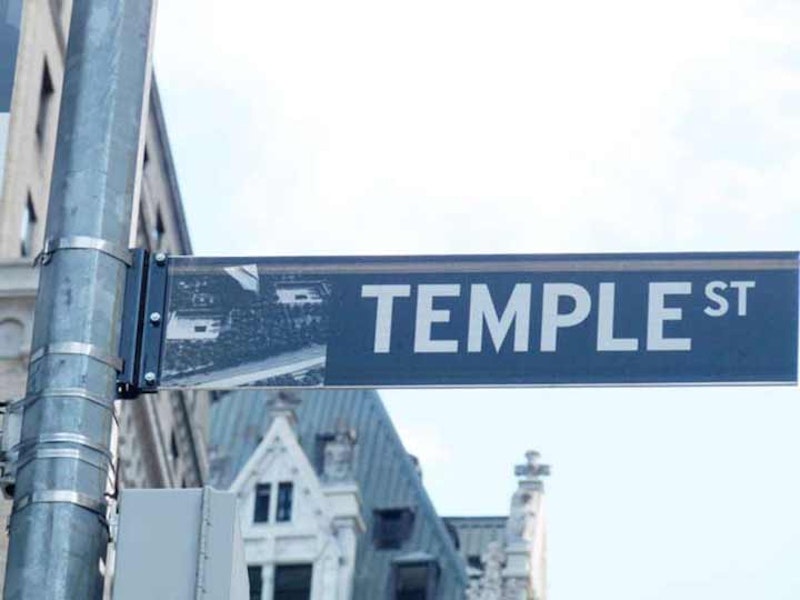
While passing through the Financial District, I’ve always noticed a green and white street sign saying “Temple Street” attached to a lamppost on Liberty St. between Broadway and Trinity Place/Church St. But there’s no street, just the sign. The Downtown Alliance has since replaced the old green and white sign with one of their stylized black and white signs, with an image of the new WTC Memorial.

On this 1916 map, Temple St. (circled in red) runs for just one block, from Cedar north to Liberty. It was reduced to one block in 1907, when the Trinity and U.S. Realty Buildings, both tall Gothic towers built to complement Trinity Church, were constructed on both sides of Thames St.
In 1967, it was decided that Ernest Flagg’s 1908 Beaux Arts skyscraper Singer Tower, one of the most identifiable buildings in the Manhattan skyline located on Liberty and Broadway, should come down. Singer, the sewing machine giant, moved out in 1961 and U.S. Steel had purchased it in 1964. As big as the tower was, U.S. Steel found the offices and interior spaces too small and wanted a modern structure. This was before the Landmarks law had passed and pretty much anything was fair game (Pennsylvania Station was also a casualty in the same era); therefore Singer came down and the forbidding U.S. Steel Building, later renamed One Liberty Plaza, was constructed in its place, opening in 1973. It has hosted Goldman Sachs, Empire Blue Cross and Blue Shield, and many other Wall Street and insurance firms. In 1968, when the Singer Tower came down, the small parcel across the street between Broadway, Trinity Pl., Cedar St. and Liberty St. became Liberty Plaza Park, and the last piece of Temple St. was eliminated.
As part of the 2006 renovations the park was renamed for John Zuccotti, NYC Deputy Mayor in 1975 under Abe Beame, the chairman of the Real Estate Board of New York, and of Brookfield Properties, which owns the park. In late-2011 and early-2012, Zuccotti Park was the staging area for Occupy Wall Street‘s protest against economic inequality and it became known worldwide as hundreds, if not thousands, gathered in the park for several months. Today, the sign is all that remains of Temple Street, and why the Department of Transportation continues to mark it is unknown.

A sign on the east side of Broadway, just south of W. 125th and in front of the General Grant Houses, advertises the presence of a Moylan Pl. However, there’s no Moylan Pl.—just the sign.

This 1949 Hagstrom map segment shows there was a Moylan Pl. between Broadway and W. 125th at Morningside Ave. The NYC Housing Authority website reveals that the Grant Houses were built in 1957, and that’s presumably when Moylan Pl. was plowed under. Since 1949, there have been plenty of changes to the Manhattanville map. For example, the neighborhood is one of the oldest in the borough and had been thriving since colonial times, and has its own small street grid that’s independent of the John Randel Jr. 1811 survey that determined the streets surrounding it. One big change has already been made: Manhattan St. has changed to W. 125th. Later, Lawrence St. would become W. 126th. The Grant, Manhattanville and Morningside Houses would eliminate some of the side streets. The Convent of the Sacred Heart would become the South Campus of CCNY.
Moylan Pl.’s street sign is a puzzle, since the street was eliminated 55+ years ago. The street does have a connection with the late George Carlin, the great comic and social commentator. In his autobiography Last Words, Carlin writes: “The Moylan [Tavern] was on a street that’s long gone called Moylan Place. Right under the El, off Broadway near 125th Street. They built a project over it. It was the classic New York saloon. Being on the common border of several neighborhoods, it had great cross-cultural influences. There were blacks and Puerto Ricans of all trades, seminarians from the Jewish Theological Seminary and Union Theological Seminary, Irish construction workers, cops, firefighters, students and professors from the Juilliard School of Music, Columbia and Teachers College, retired pensioners and young Irish bucks trying to earn their wings, every type of New Yorker rubbing up against one another and most of the time in a peaceful manner.”
Carlin went on to describe how he introduced his future wife, Brenda, to his crowd in the bar and how one of her falsies came loose as she was playing pool.

When Forgotten New York was just getting started back in 1999, I got word there was a hidden street in the Bronx, unmarked on maps and by the Department of Transportation. The alley, known as Garden Pl., was accessible only by an alleyway on White Plains Rd. south of E. 240th St. I went up there, recorded the alley, which is a dirt road in a tough part of town, and mostly forgot about it.

The earliest map in which I can find a reference to Garden Pl. is this Hyde map from around 1900, when Garden Pl. was part of a (probably proposed) real-estate development called South Vernon Park, likely so-named because it was just south of the town of Mount Vernon. Garden Pl. ran, then as now, just east of White Plains Rd., with just an alley or two connecting the two thoroughfares. Given other maps I discovered, I had doubts that South Vernon Park had been developed, since the late Bronx historian John McNamara doesn’t mention it at all in History in Asphalt. However, I did find a 1935 court case that said it’d been surveyed and laid out around 1890, became part of the village of Wakefield and was subsequently absorbed into the City of New York, which then included just Manhattan and the Bronx, in 1895.
On the map shown above, some streets are still on the NYC map: Garden Pl., Osman Pl,, St. Ouen (St.) and Penfield Ave.. Today only Garden Pl. remains, while the rest of South Vernon Park has been eliminated, if it was ever built.

There are two Floral Parks, a neighborhood in eastern Queens generally east of the Cross Island Parkway between Hillside Ave. and Jericho Turnpike, and a municipality in Nassau County south of the turnpike. On the undefended border of Queens and Brooklyn, the borders were redrawn along existing streets long ago, to eliminate the possibilities of the borough lines running through homes. No such nicety was done, however, for the city line of Queens and Nassau, which was drawn when Nassau broke away from Queens to form its own county in 1899. When that line was created, there wasn’t yet a street grid at all, which was built up after World War II. 257th St. runs north to south in Floral Park, and meets Jericho Turnpike just south of the city line, leaving a small wedge of the street in Nassau County. That wedge was named Keene Ave. and in the above photo, exists below the manhole cover.

I first found it in the late-1970s, on one of my many bicycling trips from Bay Ridge way out east, to New Lots, Ozone Park or even further. The longest round trip I ever made was Bay Ridge to Valley Stream and back. One of my favorite routes was down Cozine Ave., to escape the mean streets of East New York further north; this was the blackout–Son of Sam era. Reaching Fountain Ave., I noticed a dirt road just south of Cozine running east to Crescent St. It was unpaved and there must’ve been a black and white street sign indicating “Old Mill Road.” The city doesn’t deign to mark it today, though there’s a single streetlamp. There appear to be two or three ancient homes fronting the road, which explains its survival.
I hadn’t the time to board the Q8 or B13 buses, both of which run past the old road on their way to the Gateway Center Mall. All NYC boroughs have a Mill Street, Lane, Road of some kind, and all of them are near the water and mark the locations of former mills. Crescent St. used to run down to Jamaica Bay and was the location of Van Wicklen’s Mill: “Located at the foot of Crescent St. by Jamaica Bay, the Old Mill was not known to my generation.
From Good Old East New York: “The Old Mill was established on the Bull Creek, about 1770 by one Van Brunt, at the same time as the Red Mill, just across the Flatlands town line, was built. Until 1810 the Bull Creek Mill stood at the second floodgate about a half mile south of the present site. In that year the mill was taken down and the present structure was built from the timbers of the original mill, at the foot of Crescent St. The mill was owned by L. Van Wicklen and known to many as Van Wicklen’s Mill.” The East New York Project
That mill has disappeared, but its access road exists. Sometimes, dirt roads unknown by most are the keys to the historic past.
—Kevin Walsh is the webmaster of the award-winning website Forgotten NY, and the author of the books Forgotten New York (HarperCollins, 2006) and also, with the Greater Astoria Historical Society, Forgotten Queens (Arcadia, 2013)