
Riverdale, in the northwest Bronx between approximately W. 246th St. on the south, the Yonkers city line on the north, the Henry Hudson Parkway and Riverdale Ave. on the east and the Hudson River on the west (and by the communities of North and South Riverdale) is one of the city’s most wealthy neighborhoods. It features some of the borough’s most beautiful homes along country lanes that are sometimes without sidewalks, and some have only been paved within the last couple of decades.
Riverdale was developed beginning in 1852 as one of New York’s first “railroad suburb” by five wealthy businessmen who desired a community located along the New York Central’s only railroad station between Spuyten Duyvil and Yonkers. There were originally seven large estates (that remained intact until 1935) that were subsequently subdivided.
Riverdale was occupied long before 1852, however, first by the Lenape Indians; then as the estate of Adriaen Van Der Donck, a lawyer and landowner from Breda, Netherlands beginning in 1646 (whose honorific, Jonkheer, or “young lord” later became the name of the city of Yonkers); Frederick Philipse (whose bridge spanning the Harlem River, known as Kingsbridge, gave its name to many Bronx placenames); farmer George Hadley, whose house still stands near Van Cortlandt Park; and then by William G. Ackerman and other wealthy families, such as the Schermerhorns and Delafields, in the 1830s and 1840s. All recognized the area for its beauty but also for the relative proximity to Manhattan via Broadway, then a carriage road. The Hudson River Road (later NY Central and now Metro North) arrived in 1850: W. 254th St. was originally an access road from Ackerman’s property to the tracks.
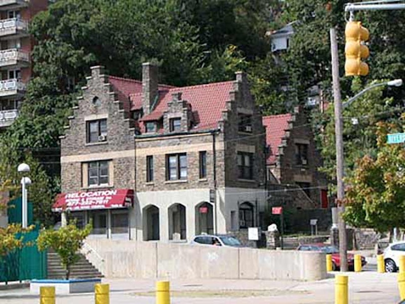
W. 230th St. in Riverdale runs from Broadway west to Riverdale Ave. Spuyten Duyvil Creek, now depressed into the city’s underground water system, partially followed the path of this street between Tibbett Ave. and Broadway. W. 230th continues for three blocks west as the city’s longest step street up a steep hill, eventually reaching Netherland Ave., while Johnson Ave. continues sharply south to southern Spuyten Duyvil. At Johnson Ave. and the steps you’ll find the handsome Flemish-style dwelling shown at the top. In colonial days, Revolutionary Forts #2 and #3 stood just south of this location from 1776-1781.

In contrast to its name, Riverdale Ave. actually runs along a high ridge. A large retaining wall was placed along the avenue between Ewen Park and W. 246th St. several decades ago, with a southbound section of Riverdale Ave. running atop the wall. It has collapsed a couple of times over the years, most recently in 2002.
Know your “stones.” Riverdale has both a Greystone Ave. and a Blackstone Ave. I’d thought Greystone may have been named for the multi-colored stones in the Great Wall, but instead it honors the former William E. Dodge estate, Greyston, once the residence of NY State Governor Samuel Tilden, who outpolled Rutherford B. Hayes in the popular vote in 1876 but lost in the Electoral College. (Blackstone Ave. was named for the black-crystalled Fordham gneiss prevalent in the area.)

Riverdale Ave. runs through the business section of Fieldston, which remains a largely Jewish enclave. Fieldston was laid out in 1914 by architect Albert Wheeler, hired by the Joseph Delafield estate to develop the region for residential properties. Winding roads were built that followed the region’s natural topography, in contrast to Manhattan island, whose hills had been leveled and streams forced underground into sewers. Fieldston languished, however, well into the 1920s and its residents formed the Fieldston Property Owners Association, which set strict standards for houses built here.

A Riverdale touchstone is its 500-ton bell tower by architect Dwight James Baum, who built over 100 residences in the area as well as the unusual YMCA building on W. 63rd St. near Central Park. Located at the confluence of Riverdale Ave., the Henry Hudson Parkway and W. 239th St., it was moved from its original location 700 feet to the north when the Parkway was constructed in 1936. The tower was built to house a Spanish bell cast in 1762 for a Mexican monastery, captured as spoils of victory during the Mexican War (1846-1848) by General Winfield Scott. The bell was originally placed in the fire lookout tower at Jefferson Market (6th Ave. and Christopher St. in Greenwich Village) then at a now-demolished Riverdale firehouse. It attained its final home here at the tower in 1930. Three of the four sides of the tower have plaques inscribed with the names of all Riverdale, Kingsbridge and Spuyten Duyvil residents who served in World War I. Architect Baum’s name is inscribed in a colorful terra cotta plaque.

Gneiss is nice, that’s what they say. As Riverdale Ave.’s route is assumed by the Henry Hudson Parkway for a mile or so, there are some interesting residences along the Henry Hudson. There is also a generous helping of bedrock gneiss that can frequently be seen at intervals in Manhattan and the Bronx.

Christ Church (Episcopal) can be found at the HHP and W. 252nd. The country chapel was constructed by renowned ecclesiastical architect Richard Upjohn (1802-1878) in a rural Gothic style in 1866. The church, and its next door parsonage, remain in appearance largely as they were when built. The chancel windows were constructed by British architect William Wailes. Upjohn’s masterwork in NYC is Broadway’s Trinity Church, constructed in 1846. Other Upjohn churches in NYC, such as St. Saviour’s in Maspeth, have not fared as well through time; threatened by a developer, St. Saviour’s was disassembled and put in storage in 2009 and awaits reconstruction… somewhere.

Vinmont Veteran Park can be found at the Parkway and W. 254th. You’ll also find the dead-end private Vinmont Rd. on Mosholu Ave. and W. 254th—both are named for NYC Parks Department playground developer Robert C. Weinberg, who playfully named them for himself. The French Vinmont and the German Weinberg both mean “wine mountain.”

In Bronx historian John McNamara’s great book, McNamara’s Old Bronx, he mentions a “Jumbo’s Corner” at Riverdale and W. 258th. Around 1900 there was an inn at the corner, the Riverdale inn, run by a large man named William Olms, 300 pounds, and was good-naturedly called Jumbo. It’s likely that very building shown above housed the inn.
W. 258th is one of the Bronx’s hidden gems. Once known as Coogan’s Lane, a walk to its dead end will reveal picturesque bungalow-like dwellings as well as another dead end, the unmapped Schaefer’s Lane.

Last stop on Riverdale Avenue in the Bronx is the College of Mt. St. Vincent. This school has its roots in the old Academy of St. Vincent, founded in 1847 in upper Manhattan on ground now occupied by Central Park. When the City authorized the construction of Central Park in 1853, the Sisters of Charity, who ran the academy, cast about for a new locale and found one in 1855 in what was then part of Westchester County, the estate of the Shakespearean actor Edwin Forrest.
Forrest’s home, Fonthill, is still on the property. The Academy became the College of Mt. St. Vincent in 1911. Above we see the well-guarded main building. Among the college’s graduates are Corazon Aquino (1933-2009) former President of the Philippines, and the late Bernard McGuirk, “bald-headed stooge” (as Don Imus called him) producer and on-air personality on the Imus In The Morning and Bernie and Sid radio shows until his untimely death in 2022.
—Kevin Walsh is the webmaster of the award-winning website Forgotten NY, and the author of the books Forgotten New York (HarperCollins, 2006) and also, with the Greater Astoria Historical Society, Forgotten Queens (Arcadia, 2013)