
What happens when two streets in the same borough have the same name? Nothing much, but it’s a rarity in New York City. This is deliberate. The opposite used to be the case. Before four New York State counties were combined to form Greater New York City in 1898 (the fifth county, the Bronx, was separated from New York County in 1914) the counties were made up of individual towns: in Kings, there was the city of Brooklyn, Bushwick, Flatbush, New Utrecht etc.; by 1895, they’d been absorbed into the then-City of Brooklyn. In Queens, there was Newtown, Flushing, Jamaica et al. Probably the least known of these towns were in Staten Island, which featured the towns of Southfield, Northfield, Castleton etc.
After Greater New York was formed, the towns were dissolved as the counties became boroughs. However, street names could be duplicated in more than one of these towns. Every town could have a Washington St., a Spruce St., etc. Post offices were confused. City management renamed the streets so these duplications could be eradicated. The form of these changes differed by borough. Between 1912 and 1930, Staten Island renamed most of its streets, and duplications were mostly avoided. While some main roads were unchanged, Richmond Turnpike (established by Vice President Daniel Tompkins in the early-1800s) became Victory Blvd. while Fresh Kills Rd. became Arthur Kill Rd.
Queens was a different story. That borough’s Topographical Bureau numbered all the streets—and created even more problems in neighborhoods like Maspeth where it seems every street is numbered 59 or 60.
In Boston, no one seems to mind. Multiple streets in different neighborhoods have the same names and there are at least four Washington Sts,, with many other multiple “name’s the same.” In Philadelphia, uninterrupted streets are rare, and sometimes the interruptions are so extreme that two “pieces” of the same street are miles apart, though they were mapped as the same street, albeit interrupted.
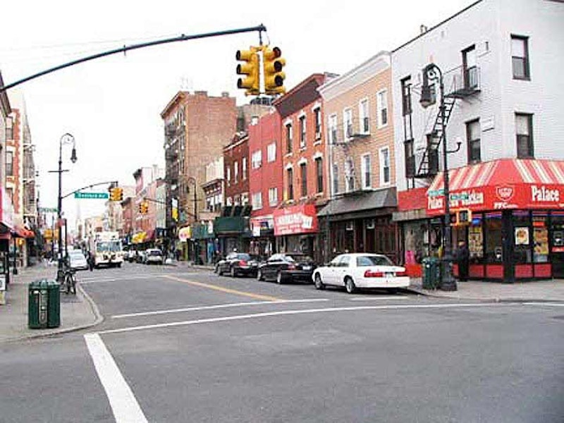
In Brooklyn, most of these duplications were caught and changed. However, there’re still street name duplications, which I’ll discuss here. At the top is a photo of Manhattan Ave. in Greenpoint. Manhattan Ave. runs in a general north-south direction from Brooklyn’s Broadway north to Newtown Creek; it forms the heart of Greenpoint and is the main north-south shopping street. It’s been called Manhattan Ave. for only 120 years or so; before that, parts of it were called Ewen St, and Union Ave. It’s the height of deference for a Brooklyn route to be named for its rival across the East River. Can you imagine a main drag in Manhattan named for Brooklyn?
While Manhattan itself has a Manhattan Ave., its two Manhattan Sts. have all but vanished. Manhattan St. was renamed 125th St., and a shorter Manhattan St. ran along the west edge of PS 188 north of E. Houston St. Letters on the building identify it.

Sea Gate is a walled-off community at the west end of Coney Island, in an area once called Norton’s Point. It’s impenetrable; those waving cameras at Checkpoint Charlie at the west end of Surf Ave. are sent on their way. I once surreptitiously got in, and have a few photos to show for it. I was using a film camera and was limited in the number of photos I could squeeze off, and none were on Sea Gate’s Manhattan Ave. The Google Street View truck has similarly not been allowed in, and so photos of Sea Gate are rare. Here’s a map showing Sea Gate’s Manhattan Ave., which I’ve outlined in red.
Sea Gate also has a “duplicate” Atlantic Ave.; the one open to the public runs from the Upper New York Bay waterfront in Brooklyn Heights all the way east to the Van Wyck Expressway. The Long Island Rail Road runs above or below it for most of its length.

West St.’s name in Greenpoint is easy to explain: it’s the westernmost north-south street in the neighborhood, paralleling Franklin St., Manhattan Ave. and McGuinness Blvd.

West St. in Gravesend, which runs from Ave. T south to the Belt Parkway between E. 1st and W. 1st Sts. is west of something, in a matter of speaking. Gravesend uses the street numbering system designed for Flatbush, with north-south oriented streets running east and west of Gravesend Ave., renamed McDonald Ave. in 1930. McDonald Ave. stands in for E. 1st St. north of Kings Highway, while Dahill Rd. is the longitudinal “0 Street.” However, McDonald Ave. zigs to the southwest south of Kings Highway and so an E. 1st St. was laid out to take its place, and west of that, Dahill Rd. was replaced by West Street—which sits to the west of the East numbered streets. Confused? South of the Belt Parkway, an east-west road called West Ave. runs past Lincoln High School.

W. 9th St. is on the outskirts of Red Hook at the south end of Carroll Gardens and is a western extension of 9th St., running from Smith St. west to Columbia St.. Maps made before about 1900 show it as Church St.
The first 9th St. bridge crossing the Gowanus Canal was completed in 1905; in 1999, the bridge reopened after a complete renovation. In the 1930s, a massive railroad trestle carrying the IND subway was built over it. My educated guess why Church St. became W. 9th is that the city wanted to continue 9th St. further west after the bridge opened in 1905, but didn’t want to renumber all the houses on the street all the way to Prospect Park, which they’d have to do. So, W. 9th St. it was.
W. 9th St. in Gravesend, meanwhile, is more mundanely named as it parallels W. 8th and 10th Sts., running from Bay Parkway south to 86th St. Like the West streets, the West 9ths are so far apart that no one except people new to Brooklyn gets confused about them.

Stewart Ave., now reduced to a few interrupted unpaved blocks between Ovington Ave. and 74th St. east of 6th Ave., was in the 19th century a main north-south drag in Yellow Hook, part of the town of New Utrecht. When Yellow Hook became Bay Ridge and street grid was imposed on it, Stewart Ave. lessened in importance and faded away, except for a couple of blocks with existing residences. The city doesn’t pave it and provides no street lighting.

In East Williamsburg, miles to the north of Bay Ridge, Stewart Ave. was laid out in the 19th century as a continuous north-south avenue running between Flushing and Meeker Aves. in East Williamsburg, a couple of miles at least. However, the entire road was never built as laid out; the English Kills interrupts it, as well as the vast East Williamsburg Industrial Park. As with other Brooklyn duplicates, the two Stewart Aves. are miles and miles apart and no one mistakes one for the other, except for a few Uber drivers who are new in town.

In Sheepshead Bay, there are two separate Sheepshead Bay Rds., separated by about one mile. One branches off from Neptune Ave. at W. 8th, coming to an end at the Culver El at W. 6th (where there’s an interesting McDonald’s that until recently employed Ronald McDonald’s predecessor, Speedy).

The other Sheepshead Bay Rd. runs generally northwest from Emmons Ave., petering out at Gravesend Neck Rd. at West 12th St. While they’re separated now, these two Sheepshead Bay Rds. were once joined, with the missing section running along the now-vanished Brighton Beach Racetrack. The sections were separated as early as the 1880s, with 130 years’ worth of changes along the interim territory since. Emmons Ave. assumes some of the path of the connecting section.
—Kevin Walsh is the webmaster of the award-winning website Forgotten NY, and the author of the books Forgotten New York (HarperCollins, 2006) and also, with the Greater Astoria Historical Society, Forgotten Queens (Arcadia, 2013)