
Southeastern Brooklyn reveals an unbroken street grid of monotony. Still, between about 1968 and 1993, when I moved to Flushing, it was my unbroken grid, and I employed it in the following decade to bicycle from Bay Ridge to Canarsie, Ozone Park, Valley Stream, or any area that was more or less a straight line east of my home. I forayed to northern Brooklyn, too—Williamsburg, Bushwick, and Greenpoint were vastly different than now—but I was most familiar with Marine Park, Midwood, East Flatbush, mainly because they happened to be on my route.
From 1978-1981 I worked in the Brooklyn Business Library, in a building long torn down, stacking books, arranging magazines, cleaning tables. I got a look at their full collection, one of which was a flaking, yellowing copy of the Belcher-Hyde Brooklyn desk atlas, produced in 1929. 1929 was a time when the modern Brooklyn street grid was being finally built on, especially in southern districts where development had been moribund. That meant that many of Brooklyn’s original colonial-era roads were still in place, even as development was displacing them. I thrilled to see the dirt tracks I’d glimpsed on my bike rides through areas like East Flatbush, Midwood and Canarsie shown on the atlas with names inscribed in black and white on the printed page. Years later, I got a look at a near-mint collection of the desk atlas at collector Brian Merlis’ house, where he undoubtedly keeps it under lock and key. But now, anyone can get a glimpse at it, by checking the online Historic Map Works. I’m not shilling for them but their material has been a great assistance.
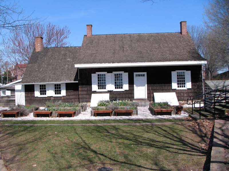
Those living in East Flatbush in the late-1960s, and early-1970s, would never mistake the well-kept country house at Clarendon Rd. and Ralph Ave., shown at the top, for the broken-down shack that it used to be. During its darkest days, the seeds were sown for the revival of what’s agreed by many scholars to be the oldest house in NY State, as the Pieter Claesen-Wyckoff House gained recognition for its lengthy history by the NYC Landmarks Preservation Commission, established in 1965.
Pieter Claesen Wyckoff (1625-1694) arrived in America in 1637. He was a 12-year-old illiterate indentured servant who worked for the patron Kiliaen Van Rensselaer near Albany, until his servitude expired in 1644. By 1652, he was living in New Amersfoort (Flatlands) and became a supervisor on a farm belonging to Peter Stuyvesant, governor of New Netherlands, acquired some property, and became a town magistrate. In time, he was New Amersfoort’s wealthiest citizen. He built this house along the now-defunct Canarsie Lane in 1652; at the time it was situated on one of the higher hills in town, later leveled. When the British took over in 1664 the house became the property of the Duke of York, but later reverted to the Wyckoff family, which occupied it into the 20th century. The Pieter Claesen–Wyckoff House is one of about a dozen Dutch farmhouses still extant in Brooklyn, all of which were built between 1652 and 1825.

The house’s caretakers have preserved such highlights as a divided Dutch door, roof timbers, floorboards, and bedroom hearth. For the most part the roof timbers and floorboards are the originals. Decades’ worth of layers of paint had to be scraped off to reveal the wood beneath. The kitchen, the building’s oldest section, has a low, heat retaining roof. By 1750 an east wing was added, and the central hall was built by 1820, when the building attained its current appearance. The building’s artifacts include a document affirming Wyckoff’s allegiance to the King of England (sincerity unclear), a 17th-century pistol, and a hand-sewn initialed stocking worn in the 19th century by Pieter’s descendant, Cornelius Waldron Wyckoff.

In classic Brooklyn fashion, New York State’s oldest house is ensconced in a maze of car washes, junkyards, and flat fix shops that line Clarendon Rd. and Ditmas Ave. For several decades the Colonial Gas station and Garage occupied the front lawn between the house and Clarendon Rd., so that the Wyckoff house was virtually invisible from Clarendon. When I first encountered the Wyckoff house in the late-1970s and 1980s, a colonial-era road, Canarsie La., still existed in this area and ran in front of the house.

A small piece of old Canarsie La., this one marked by a street sign, runs between Ralph Ave. and E. 83rd across from the Wyckoff House. The Paerdegat Basin once extended far into the area, as Paerdegat Creek, and formed the zigzag boundary between the towns of Flatbush and Flatlands. The name comes from two Dutch words meaning “horse” and “gate.” Property lines formed the main boundaries during this time.

Moving on past the junkyards of Ditmas Ave. and turning north on E. 57th, we find Nazareth Regional High School. A frequent opponent of my Cathedral Prep high school sports teams (we usually lost), Nazareth’s first graduating class was in 1966 and the school became co-ed in 1976. NBA player and now-retired coach Mike Dunleavy Senior is a graduate; his Number 44 jersey is retired at Nazareth. His son, Mike Jr., also excelled in the NBA. (St John’s University and Golden State Warriors star Chris Mullin was an East Flatbush resident.)

Amersfort Park, bordered by E. 38th and 39th Sts. and Aves. I and J, is a pleasant surprise. It’s atypical of NYC neighborhood parks in that there are no athletic fields or even jungle gyms or swings—it’s just a pleasant green space with lawns, paths and benches. A former name for Flatlands is “New Amersfort” and the rock is a copy of a 200,000-year old rock found in Amersfoort, Holland.
The nickname for Amersfoort, Keistad (“stone city”), originates in the Amersfoortse Kei, a boulder that was dragged into the city in 1661 by 400 people because of a bet. This story embarrassed the inhabitants, and they buried the boulder in the city, but after it was found again in 1903 it was placed on a prominent spot as a monument.

Continuing west on Ave. I, between E. 34th and 35th are some of the most beautiful attached multi-family homes in Brooklyn. Bay fronts (some with surviving crenellation), arched windows, cornices—these have it all. Original crenellation, iron gates, the light brown brick I admire and original wrought-iron gates.
Victorian houses in East Flatbush (including those pictured around Amesfort Park) are all that remain of the first Victorian development in Flatbush–Vanderveer Park, which was begun in the 1892 and was developed in five phases. It was financed by the Germania Rail Co. and predated Prospect Park South, which is often referred to as the first such community in Flatbush. At the turn of the century, Vanderveer Park was significantly larger than all of the surviving Victorian Flatbush enclaves. The isolated Victorians around the now-closed Sears on Bedford Ave. and Beverly Rd. in Flatbush were also part of Vanderveer Park.
Vanderveer Park was a development sponsored by Henry A. Meyer’s Germania Real Estate Company, which in 1893 purchased acreage from the Vanderveer Farm. At the time there was talk of a Flatbush annexation to Brooklyn (which happened in 1894) and Meyer set about covering newly-cut streets with ornate Victorian-era buildings. The name Vanderveer Park survives in the Vanderveer Park United Methodist Church at Glenwood Road near E. 31st St. And, there had been a Germania Place, connecting Campus Rd. and Flatbush Ave. north of Ave. H at Brooklyn College, but in 1959 it was changed to honor the nearby Brooklyn College Hillel building, named for the first century AD Jewish religious philosopher.
—Kevin Walsh is the webmaster of the award-winning website Forgotten NY, and the author of the books Forgotten New York (HarperCollins, 2006) and also, with the Greater Astoria Historical Society, Forgotten Queens (Arcadia, 2013)