
I haven’t paid much attention to Ridge Blvd. in the past, even when I lived in Bay Ridge from 1957 through 1993. I’m concentrating here on those blocks where Ridge Blvd. evolves from the suburban-like Bay Ridge to the gritty urbanity of Sunset Park. Even the name of the street changes, from Ridge Blvd. to 2nd Ave. In Bay Ridge, the numbered avenues begin at 3rd Ave. There are three more north-south avenues west of 3rd, but they’re called Ridge Blvd., Colonial Rd., and Narrows Ave., before the original shoreline at Shore Rd. is reached. Old maps show Ridge Blvd. and Colonial Rd. as 2nd and 1st Aves., respectively, but I have a Kings County map showing 1st and 2nd Aves. in 1890 and Ridge and Colonial in 1910, so the change was made sometime in between.
I don’t know why the change was made. Bay Ridge was an outlying suburb until the 1920s, with rich nabobs’ mansions lining the shoreline, and scattered farms further inland. It wasn’t until the BMT Subway pushed south to 86th St. in 1915 did any massive real estate development happen, with side streets built up and “affordable” houses lining them.
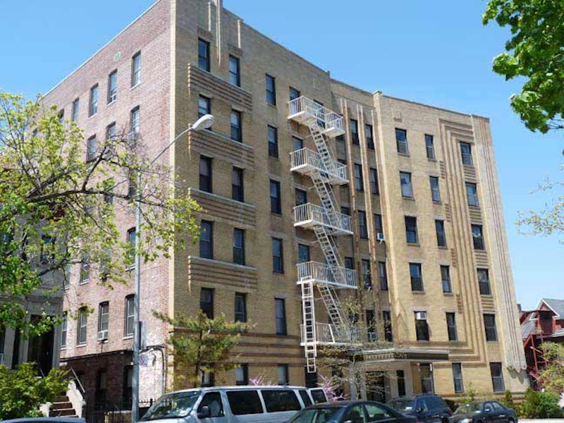
Up top, we see an Art Deco apartment building at Ridge Blvd. and 67th St. Notice the angle the building takes. It’s following a bend in Ridge Blvd., the same bend that all north-south Bay Ridge avenues take at 67th. In the late-1800s, 7th Ave. was laid out at a diagonal against the overall Brooklyn street grid south of 65th St., and its brother avenues take an angle to remain parallel with it. I have an intriguing Beers Atlas of the town of New Utrecht from 1873, and it shows just a few streets traversing through what would be Bay Ridge. Third and 4th Aves. are already established, but 86th St. and 7th Ave. are just ghost lines. As for the building itself, it features intricate brickwork and plenty of right angles in the facade.

Many people in Bay Ridge call their neighborhood “The Ridge,” but this massive multi-family on Ridge Blvd. and 75th St. (they don’t call it Bay Ridge Parkway) has claimed the title. It’s so big, it has two addresses. One of the truest ways of detecting a true “Bay Ridger” is what they call Bay Ridge Parkway and Bay Ridge Ave. They never use those names; instead, it’s “75th St.” and “69th St.” respectively, as those would be the numbered names had they still been in use. 75th descends on a slope toward the Narrows. On its brother streets, 74th and 76th, the slope is too sharp an angle for vehicles, so steps streets were built, among a handful of such on Brooklyn. Manhattan and the Bronx, meanwhile, number step streets in the dozens.

This Queen Anne-style house, just past Senator St. (Bay Ridge Ave.; over a dozen Bay Ridge streets have “Bay,” “Ridge” or both in them) is the parish house for the St. Andrew the Apostle Catholic Church (founded in 1971; obviously a private residence was purchased for it). The church itself consists of a brick ground floor constructed around a pre-existing corner house in 1981. The parish was formed when the Bay Ridge Towers on 65th St. between 3rd and 4th Aves. was completed in 1971, overwhelming the pre-existing Our Lady of Angels (4th Ave. and 73rd St.) parish.
In the New Testament, Andrew was the brother of Simon Peter and shared his profession, fishing. According to tradition he shared the fate of Jesus Christ and Peter, that of crucifixion. Not considering himself worthy to be crucified on the t-shaped cross used for the Christ, he requested an x-shaped cross, today known as “St. Andrews’ Cross.” Such x-shaped crosses were included in the architecture of Manhattan’s St. Andrew’s Church at Foley Square.

From 1938-1940 the Circumferential Parkway was constructed in western Brooklyn along the shoreline into Queens, joining a network of roads such as the Cross Island Parkway and Southern State Parkway. When that name proved to be too much of a mouthful, it was changed to the Belt Parkway, though highway and street signs call it Shore Parkway.
This overpass, dating to 1940 with several improvements since, originally connected the Belt Parkway to the Gowanus Parkway on 3rd Ave., which was built between 38th and 65th Sts. in an ingenious manner: it used the pillars and supports of the old 5th Ave. elevated train, which ran down 3rd Ave. in Sunset Park.
20th-century road czar Robert Moses was history’s greatest traffic mover, but he’s also remembered as a neighborhood destroyer. The uninterrupted shadows caused by the Gowanus Parkway over 3rd Ave. brought crime and economic depression, some say (especially Moses biographer Robert Caro) and brought on Sunset Park’s reputation as a place where, as my parents used to tell me as a kid, “the bad boys are.”

At the Belt Parkway overpass Ridge Blvd. becomes 2nd Ave. The Brooklyn Army Terminal complex is a massive grouping, filling the area between the waterfront and 2nd Ave. between the railroad and 58th St. The complex was also known as the U.S. Army Military Ocean Terminal and the Brooklyn Army Base, as part of the New York Port of Embarkation. It was designed by Cass Gilbert and completed in September 1919. It was the largest military supply base in the United States through World War II. By the time the base was closed in the 1970s, over three million soldiers and 37 million tons of military supplies had passed through the terminal. The 95-acre complex had its own railroad line, police and fire departments.
The Feds sold the complex to NYC in 1981, and since then it’s been home to light manufacturing, back offices and warehousing. Its interior open space is phantasmagorical. Unused train tracks connecting to the LIRR Bay Ridge branch can be found within. This was a major embarkation point for US troops heading to Europe and elsewhere in the draft days, and the draftees were often brought in from the mainland along the tracks.

Yet another huge brick behemoth can be found occupying the entire block between 2nd and 3rd Aves. and 58th and 59th Sts., and again occupied by small businesses. What was its purpose?
The Brooklyn City Railroad, incorporated in 1853, ran horsecar and later trolley lines in western Brooklyn for decades. This complex for repair and storage of the cars was built in 1892 at what was then the city of Brooklyn’s southern limit. The company continued to run Brooklyn’s trolleys until 1929, when the BMT (Brooklyn-Manhattan Transit) reformulated it into Brooklyn-Queens Transit. The boroughs’ trolley lines had disappeared by the mid-1950s.

Lutheran Medical Center, 2nd Ave. and 56th St., now part of the massive NYU Langone hospital system. Lutheran was founded in 1883 by a Norwegian Lutheran deaconess-nurse, Sister Elizabeth Fedde, to serve the Norwegian immigrant community. The institution has provided care for the southwest Brooklyn communities for more than 80 years. My father was treated here for his final illness in 2002-2003.
—Kevin Walsh is the webmaster of the award-winning website Forgotten NY, and the author of the books Forgotten New York (HarperCollins, 2006) and also, with the Greater Astoria Historical Society, Forgotten Queens (Arcadia, 2013)